The Tithe Location Reference database was created to help try to work around a number of location errors included in the Tithe Applotment transcripts on the National Archives of Ireland website. There are a number different types of error, the most common being those combining two or more consecutive parishes, some with the same or similar name – e.g. Donaghmore Co. Limerick and Donaghmore Queen’s County, or a following parish alphabetically – e.g. Brannocktown Co Kildare and Bray Co. Wicklow, Grangegorman Co. Dublin and Grangemaccomb Co. Kilkenny etc.
Some of the other errors seem to be due to misinterpreting the Diocese as the County – e.g. Meath or Dublin, and yet further errors do not seem to have any logical reason – e.g. Allsaints parish , Donegal is indexed under Co. Dublin.
There are two basic modes of operation for the Tithe Location Database , the initial being the Tithe Parish on the left and the associated Civil Parish on the right. This shows the Counties and Parishes based on the way they have been transcribed on the NAI system, so can be used to check which Civil Parish is actually associated with the Parish. Select the required County, and optionally part of the Tithe parish name – e.g. selecting County Dublin shows the following.
Any issues are highlighted and include notes – e.g. Allsaints noted as ‘Location Error‘ and in Co. Donegal, same with Balla in Co.Mayo. The Tithe parish of Ballyfermot is shows as a mix of parishes i.e. Ballyfermot and Palmerstown.

The link in the 3rd column is to the associated NAI Transcript page and if for those with a camera icon in the last column link directory to the image page for the correct civil parish using the IrelandGen Tithe Image Browse Tool.
The second mode available for the Tithe Location database is the reverse – Civil Parish to NAI Tithe Parish, which can be used to check if the selected Civil Parish has been transcribed, and if it has been which Tithe Parish it is listed under. To select this mode click the < Switch > link below the county dropdown.
 On the sample of Co. Wicklow Civil parishes above see that Ballykine Civil parish does not appear to have been included in the current Tithe Transcripts and displays as ‘no link found‘ , and entries for Bray Civil Parish have been mixed with those for Brannockstown Co. Kildare. The Camera icon links directly to the images of he correct Bray Applotment books(*), and the Tithe Link icon on the far right links to the NAI transcript for Brannckstown – the transcripts being a mix of the two parishes.
A batch of Applotment Books between Drung and Duncormick alphabetically appear to have been omitted from the FamilySearch films used for this project so not included in either the images or transcripts.
* Some of the townlands of Bray Civil Parish listed in later sources, e.g. Griffith’s the Townland Index etc, are included in Powerscourt Tithe parish.
p.s. many thanks to those who have provided additional corrections to include in this system.

 Additional Menu Options for Catholic & Church of Ireland Parish Details
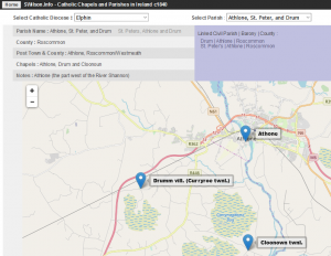
 Select Diocese and Parish
 Parish details and map of Churches as of c1840
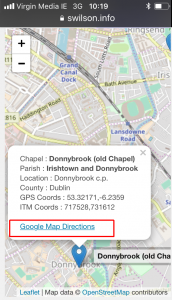
 Church Details and Coordinates (click on the marker to show)
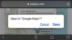
 Google Maps requests permission to access your location.
 Directions from your current location to the historic Church site.


 The Tithe Applotment record images available online on the National Archives of Ireland website, along with corresponding transcripts, have been a great addition to the resources available to those researching online – and also save a trip into Dublin city for those living closer. Since the time these were released people were reporting issues finding townlands – many due to the expected variable spellings used, but some turned out to be misclassified – e.g. a civil parish listed under the incorrect county, or a townland not listed in the expected parish.